parameters
 figure 1
inclination angle δ (figure 1) is defined between the equatorial plane and the plane described by the satellite orbit. An inclination angle of zero degrees means that the satellite is exactly above the equator. If the satellite does not have a circular orbit, the closest point to the earth is called the perigee. The farthest point from the earth is called the apogee.
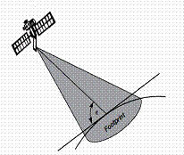
figure 2
The elevation angle ε (figure 2) is defined between the centre of the satellite beam and the plane tangential to the earth’s surface. A footprint can be defined as the area on earth where the signals of the satellite can be received.